


Offline maps on a sports watch provide essential safety and freedom by allowing people to explore without a phone signal.
Defining the Role of Topographic Maps in Modern Sports Watches
Modern sports watches use topographic maps to give users a full picture of their surroundings. Most basic watches only show a simple line on a dark screen which is known as breadcrumb navigation. Breadcrumb navigation shows where a person has been but it does not show the world around them.
Premium sports watches include detailed maps with streets, rivers, and hills. This extra detail is called a TOPO map. These maps help people understand exactly where they stand in the real world. A user can see a lake on their left and a mountain on their right. This visual context makes navigation much easier for everyone.
Detailed mapping turns a simple fitness tracker into a professional tool for exploration. Many high-end devices now offer full-color displays to make these maps look sharp. When a watch has its own map data, it does not need a connection to a smartphone to show the way.
This independence is the main reason why serious athletes choose watches with built-in mapping. This distinction is widely recognized in professional GPS navigation standards which highlight the importance of visual context for safety.
Ensuring Navigation Safety in Remote Wilderness and Zero-Signal Areas
Offline maps keep adventurers safe when cellular networks are unavailable. Many outdoor spots like deep forests or high mountain ranges have zero cell service. A standard smartphone cannot load new map data without a steady signal. This creates a dangerous situation when a hiker gets lost in a dead zone.
A sports watch has the map data saved directly on its internal storage. It uses satellites to find a person's exact location on the planet. This system is known as GNSS or Global Navigation Satellite System. The watch works perfectly in the middle of a wilderness area because it relies on space signals rather than cell towers.
Reliability is the most important factor for safety. Smartphones often fail in the cold or when they get wet. A rugged sports watch is built to handle rain and freezing temperatures.
When the phone battery dies from the cold, the watch stays on. This ensures that the user always has a clear path back to their starting point. Search and rescue statistics often show that reliable GPS tools significantly reduce the time needed to locate lost hikers.
Optimizing Athletic Performance Through Real-Time Trail Guidance
Real-time route guidance helps runners and hikers stay on the correct path to save time and energy. People often take a wrong turn during a long trail race. Stopping to check a paper map or a phone slows down the pace and ruins the rhythm. A watch with an offline map provides instant directions right on the wrist.
Many watches vibrate or make a sound the moment a person leaves the planned trail. This is called a course deviation alert. This instant feedback keeps the athlete on track without any wasted effort. Staying on the right path keeps the heart rate steady and the focus on the finish line.
Advanced maps also show elevation profiles for the road ahead. An athlete can see exactly how steep the next hill is before they reach it. This information helps them manage their energy throughout the day. They know when to push hard and when to save strength for a difficult climb. Research on athletic performance in trail running suggests that reducing navigation stress leads to faster finish times.
Enhancing the Urban Running Experience for Travelers and City Explorers
Wrist-based navigation simplifies traveling in new cities without paying for international data plans. Exploring a new place like London or Tokyo is fun but confusing. Using a phone for directions in a foreign country often requires expensive roaming data. A sports watch lets a traveler see the nearest park or coffee shop with a quick glance at their arm.
Mobile phones are also targets for theft in busy tourist areas. Pulling out an expensive phone every two minutes to check a map is not always safe. A watch is securely buckled to the wrist and is much less noticeable. This makes city trips more relaxed and keeps the user aware of their surroundings.
Travelers can use points of interest to find essential locations quickly. These points include water stations, train entrances, and public restrooms. Having these locations saved on the watch allows for a stress-free adventure.
A runner can explore a random neighborhood and always find the quickest way back to their hotel. Travel safety reports suggest keeping expensive electronics hidden to avoid unwanted attention in crowded areas.
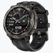
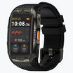
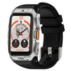
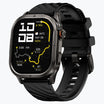
Evaluating Top Sports Watch Models: Focus on KOSPET TANK T4 and M4
The KOSPET TANK T4 and M4 stand out as powerful options that include professional mapping features at a great value. These models prove that high-end navigation is now available to more people. Both watches are built with military-grade materials to survive tough conditions. They are designed for people who want a durable tool for the outdoors.

The TANK T4 features a bright AMOLED screen that stays visible even under direct sunlight. It has 32GB of internal memory to store many different map files and thousands of songs. This large storage space is rare for watches in this price range. It allows users to carry detailed maps for several different regions at once. Industry reviews of rugged wearable technology often highlight large storage as a key feature for offline capability.
The TANK M4 has a large square screen which provides a wider view of the landscape. This extra screen space is helpful when trying to see a complex intersection or a long trail. Both the T4 and M4 use dual-band GPS technology.

This means they use two different signals to stay accurate near tall buildings or under thick trees. Accuracy is much higher than older watches that only use a single signal. This dual-band GPS technology is the current standard for high-precision location tracking.
Managing Battery Longevity and Display Efficiency During Active Map Use
Smart power management allows users to enjoy map features without running out of battery during long trips. Watching a map screen uses more energy than just counting steps. This is because the processor has to work hard to draw all the roads and hills. Users can extend their battery life by making a few simple adjustments.
Lowering the screen brightness is one of the easiest ways to save power. Another trick is to only look at the map at major intersections instead of keeping the screen on all the time. Many watches have a power-save mode that still tracks the GPS location but turns off the map display when it is not needed. These small changes help the watch last for an entire weekend of hiking.
Choosing the right screen type also makes a difference. AMOLED screens are very pretty but use more power when the map is full of bright colors. Using a dark theme for the map can help save some energy. The TANK series is built with large batteries to handle these tasks for many hours. This gives the user peace of mind during long-distance adventures. Professional smartwatch battery tests confirm that display management is the most effective way to increase GPS runtime.
Conclusion
Choosing a sports watch with offline maps is the best way to gain confidence in any environment. These tools provide a clear path forward whether a person is in the deep woods or a busy city. They offer safety when phones fail and help athletes reach their goals faster. Investing in a watch like the KOSPET TANK T4 or M4 ensures that you are always ready for the next adventure.
FAQs
Can I use offline maps on a sports watch without a phone nearby?
Yes. Once maps are downloaded to the watch storage, they function entirely through GPS signals. They require no cellular data or phone connection to show your location.
Do offline maps significantly drain the battery?
Yes. Drawing map details on a screen uses a lot of power. You should use map screens only when necessary or lower your brightness to keep the watch running longer.
What is the difference between Breadcrumb and TOPO maps?
A breadcrumb map shows a simple line on a blank background. A TOPO map shows detailed terrain, streets, and hills. TOPO maps provide much better information about your actual surroundings.


Leave a comment
All comments are moderated before being published.
This site is protected by hCaptcha and the hCaptcha Privacy Policy and Terms of Service apply.